Slm,
Hari ni terbaca artikel pasal 'Gambar satelit bukti AS mendarat di bulan' oleh satelit Chandrayaan-I milik India. Tersentak den dari lamunan pasal dah lama percaya yang AS ni menipu rakyat bumi dah berpuluh-puluh tahun yg kononnya mereka dah mendarat dibulan dengan teknologi yg teramat cikai pada masa itu. Namun, apakah mungkin dengan bukti bergambar dari Chandrayaan-I ini dapat membuktikan sesuatu kebenaran atau kepalsuan? Anda tentukan.
Maka den pun mencari info dan gambar yg berkaitan misi angkasa india ini dan dikongsi dalam satu benang khas utknya.
This image shows a closer view of the moon’s surface taken by Moon Impact Probe on Friday, Nov. 14, 2008 as it approached it after separating from India’s Chandrayaan-1 spacecraft. The first lunar probe from India landed successfully on the moon Friday as part of a two-year mission aimed at laying the groundwork for further Indian space expeditions, the ISRO said. (Pic: Indian Space Research Organization,HO)
Finally, we have a set of three images of the subset of M3 data for theOrientale region. These images contain 300 spatial elements (pixels)across the 40 km field of view, providing 140 m resolution. On the leftis one spectral band at 750 nm in which the signal is entirelyreflected solar light. The middle figure is a color composite ofprocessed data that accentuates compositional differences. The blue tored colors represent the slope of the lunar continuum in thenear-infrared. The green color is an indication of the abundance ofiron-bearing minerals such as pyroxene ( as measured by an integratedband depth derived from 26 channels of continuum removed data between790 and 1290 nm). The image on the right is a single M3 spectral bandat 2940 nm. This image contains significant thermal emission in thesignal and is particularly sensitive to small variations in localmorphology. These new data provide mineralogical constraints ongeologic processes that occur within the Orientale Basin. The dark mareregion in the north-east part of the image contains the greatestabundance of iron-rich minerals and is basaltic in composition.Although a few small areas of iron-bearing minerals occur within theimpact melt formed by the basin impact (seen along the left and bottomof the image), this material is very plagioclase rich, and severalmountains and blocks are essentially pure anorthosite.
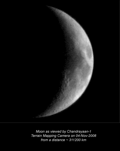
Chandrayaan-1's Terrain Mapping Camera snapped this image of the Moonshortly after entering orbit on November 13, 2008. In the lower left isa portion of the crater Torricelli C. Torricelli C (not all of which isvisible here) is 11 kilometers in diameter. The entire image isapproximately 20 kilometers across. Credit: ISRO
Bangalore India’s maiden moon probe Chandrayaan-I has developed a malfunctionthat puts some experiments in jeopardy and raises questions on completion of the mission that was intended to last two years.
“Unfortunately, during the last month we have lost a vital sensor —the star sensor,” Indian Space Research Organisation (ISRO) Chairman GMadhavan Nair said.
He said space scientists had tried to work around the problem and patched two other instruments to help manoeuvre the spacecraft to the desired locations.
“We are not sure how long we will be able to sustain it. The life of Chandrayaan-I designed for two years may be reduced,” ISRO spokesman SSatish said. Chandrayaan was launched on October 22 last year.
Nair said that in the last eight months of the mission, “we have collected almost all the data that we wanted” and that most of its objectives have already been completed.
The problem would mean that some of the 10 experiments onboard would have to be replanned and at least one involving the Lunar Laser Ranging Instrument (LLRI) being abandoned.
The LLRI was designed to measure altitude variations within five-metre accuracy and operate at a 100-km altitude, a distance at which the spacecraft was to orbit the moon during its two-year mission period.
ISRO had raised the orbit of Chandrayaan-I to 200 kms on May 19.
Referring to the efforts to keep Chandrayaan-1 going, Nair said gyroscopes as well as an antenna have been used to allow the craft to find a direction.
“We are able to continue the functions as in the past and there is no major issue as of now,” the ISRO chief added.
“I think in the last eight months of its operation, we have collected almost all the data that we wanted. In fact now what we are going to get is basically a kind of redundant data and more of a crosschecking and things like that. So that way, most of the mission’s objectives are already complete,” Nair said.
Lauding the scientist for overcoming the failure, he said it was their imagination, the promptness of action and the type of solution which were unique.
PUNE: Nearly 40 years after Nasa's Apollo flights, which put a man on the moon, India's Chandrayaan mission launched on October 22, 2008, recently did something unique this week it mapped the landing sites of the six Apollo missions on the moon and the process ended on Saturday.
The Apollo flights were launched between July 1969 and December 1972.
This hitherto unknown aspect of the Chandrayaan programme was revealed to TOI on Saturday by a top scientist associated with the Indian moon mission, P Sreekumar, who quit his job in the US to be a part of the Indian moon team. He was among the participants at the inauguration of the International Year of Astronomy programme at the Pune-based Inter University Centre for Astronomy and Astrophysics (IUCCA).
Sreekumar told TOI that that the six Apollo landing sites which were mapped related to those of Apollo 11, 12, 14 15 and 17. The process began on January 7 and ended on January 10. "Our purpose of carrying out this exercise was to validate and confirm the data through global mapping about the moon's surface and rocks which had been obtained by these Apollo flights," he said. It may be recalled that Apollo 11 placed Neil Armstrong and Buzz Aldrin on the moon, which became historical because they were the first humans to step on the lunar surface.
He said that the mapping of the Apollo landing zones were done by six of the 11 scientific payloads on Chandrayaan which included the indigenous Terrain Mapping Camera which was first activated on October 29, 1995, the Hyper Spectal Imaging Camera also from Isro, Nasa's Moon Minerology Mapper, Radom from Bulgaria and the Near Infra-Red Spectrometer (Sir-2) of Germany.
Told that the Apollo landing sites were on the equatorial region of the moon, while Chandrayaan operated in the north-south polar orbit, Sreekumar explained that even though the Indian moon mission was flying in the polar orbit, it was successfully covering the entire surface of the moon, which included the six Apollo landing sites.
He said that another instrument on Chandrayaan, the Sub-Kev Atom Reflecting Analyser (SARA), a contribution through ESA from the Swedish Institute of Space Physics, the Space Physics Laboratory and the Vikram Sarabhai Space Centre, Thiruvananthapuram, was activated this week. The role of this equipment is to image the moon's surface composition, including the permanently shadowed areas, study the solar wind interaction and carry out studies connected with space weathering.
GAMBAR menunjukkan air dikesan di bulan dengan menggunakan lampu inframerah.
BANGALORE - Sebuah satelit India, Chandrayaan-1 yang mengesahkan penemuan kehadiran air di bulan kelmarin menjadi tajuk utama pelbagai media di negara itu semalam.
Satelit itu yang dilancarkan ke orbit untuk misi mengelilingi bulan sejak Oktober tahun lalu sebelum ini mencetuskan kebimbangan kerana ia gagal menghantar balik isyarat ke bumi.
"India kini boleh berbangga apabila Chandrayaan-1 menjadi satelit pertama menemui air di bulan," kata Ketua Pertubuhan Penyelidikan Angkasa India (ISRO), G. Madhavan Nair.
Pada sidang media di sini semalam, beliau menyifatkan misi itu sebagai menakjubkan malah menutup kritikan pelbagai pihak kerana misi itu dianggap berjaya 110 peratus.
Beberapa akhbar ternama India menyiarkan berita kejayaan itu sebagai tajuk utama manakala stesen televisyen menyiarkan berita itu dengan membangkitkan semangat patriotik.
"Satu langkah besar kepada India, satu langkah gergasi untuk manusia," kata Times of India sementara Hindustan Times menggunakan tajuk Air di bulan: Chandrayaan hebat".
Sebelum ini, para saintis menyatakan bulan pada keseluruhannya adalah kering.
Misi itu melibatkan kos sebanyak AS$80 juta (RM278 juta) iaitu kurang separuh daripada jumlah yang dibelanjakan untuk misi yang sama oleh negara lain.
Perbelanjaan itu menunjukkan India berjaya menggunakan kos yang murah untuk misi tersebut.
Kejayaan Chandrayaan-1 itu mendorong India pada Rabu lalu melancarkan tujuh lagi satelit baru, enam daripadanya milik negara luar dalam satu misi penerbangan ke angkasa.
India memulakan program angkasa sejak 1963 dengan membangunkan satelit sendiri dan menghasilkan pelancar untuk mengurangkan kebergantungan kepada agensi angkasa asing. - AFP


 Post time 3-9-2009 10:12 AM


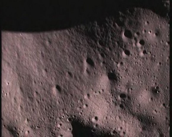
 This image shows a closer view of the moon’s surface taken by Moon Impact Probe on Friday, Nov. 14, 2008 as it approached it after separating from India’s Chandrayaan-1 spacecraft. The first lunar probe from India landed successfully on the moon Friday as part of a two-year mission aimed at laying the groundwork for further Indian space expeditions, the ISRO said. (Pic: Indian Space Research Organization,HO)


 变色卡
变色卡 Author


![[tvN/Netflix 2024] QUEEN OF TEARS - Kim Soo Hyun, Kim Ji Won, Park Sung Hoon](https://uf.cari.com.my/forumx/mforum/block/f6/f613b76788751ed27a22bff90355c844.jpg)


